warnings updated: Thursday, November 12, 2026, 5:18 pm PST
NWS San Diego Forecast Discussion – Synopsis
Issued 1235 PM PST Thu Nov 12 2026
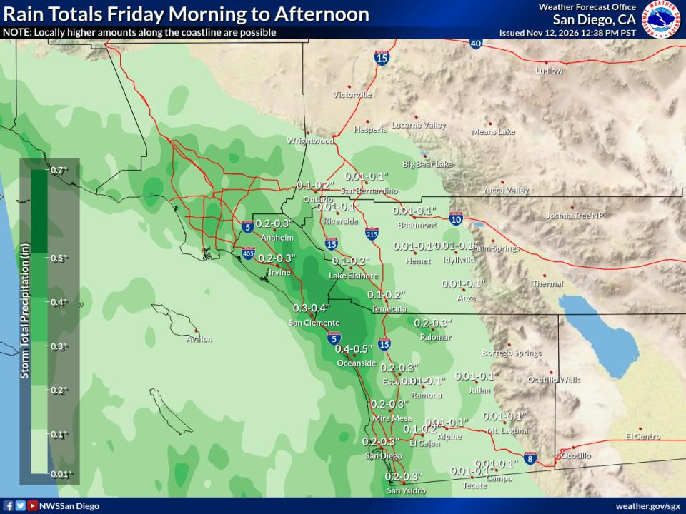
Cooler conditions with increased cloud coverage is expected through early next week. Periods of rain are expected Friday through next week. The first round is expected Friday morning, with chances of isolated thunderstorms over the coastal waters locally into the beaches. The next chance will be Friday evening into Saturday, with more widespread light to locally moderate showers. In addition to periods of rain, winds are expected to increase over the mountains, deserts, and coastal waters. Sunday could see mostly dry conditions with our next chances of precipitation and increased winds Monday through Wednesday.
Covers extreme southwestern California, including Orange, San Diego, western Riverside and southwestern San Bernardino counties.
Showers will start to move into coastal areas early Friday, with lighter rain inland for most of Friday. A stray thunderstorm is possible (~15% chance) near the coast.
Data Courtesy of San Diego Weather Forecast Office
Almanac information is for the Palm Springs Airport and is provided by the National Weather Service.
High80°normal95° record (1933)
Low55°normal34° record (1950)
Sunrise6:16am
Sunset4:45pm
Moonrise9:34am
Moonset7:10pm
Illumination10%
Evaporative Cooler Effectiveness by City
Thousand Palms
Outside Temp75°F
Dew Point45°F
Est. Output62°F
Updated: Nov 12, 5:31 PM PST
Palm Desert (Hwy 111 & El Paseo)
Outside Temp75°F
Dew Point49°F
Est. Output63°F
Updated: Nov 12, 5:23 PM PST
Palm Springs Airport
Outside Temp78°F
Dew Point42°F
Est. Output62°F
Updated: Nov 12, 4:53 PM PST
Thermal Airport
Outside Temp73°F
Dew Point46°F
Est. Output61°F
Updated: Nov 12, 4:52 PM PST
It's already a comfortable 73°F outside — running the cooler isn't needed.
How to Read This
Score
0–100, based on the wet-bulb depression — how much cooler the air could get versus the actual outside temperature. Drier air means more room to cool, so a bigger gap scores higher.
Wet-Bulb Depression
The gap between the outside (dry-bulb) temperature and the wet-bulb temperature — the coolest evaporation alone could get the air. A bigger gap means drier air and more room for the cooler to work with.
Estimated(Est.) Output
The approximate temperature of the air coming out of the cooler, estimated by cooling the outside temperature most of the way toward the wet-bulb temperature.
Efficiency
These numbers assume 80% saturation efficiency — typical for a well-maintained direct (single-stage) evaporative cooler.
Lower dew point + higher temp = better cooling
(This guide generally will work for misting systems also)